
Total Solar Eclipse’s
Path Across the U.S.
August 21, 2017
Path Across the U.S.
August 21, 2017
The moon will completely block the sun’s face,
treating part of the US to a total solar eclipse.
Everyone in North America will have the chance to see an eclipse of some kind if skies are clear. Anyone within a 70-mile-wide swath of land - called the path of totality - that stretches from Oregon to South Carolina will have the chance to see a total eclipse.
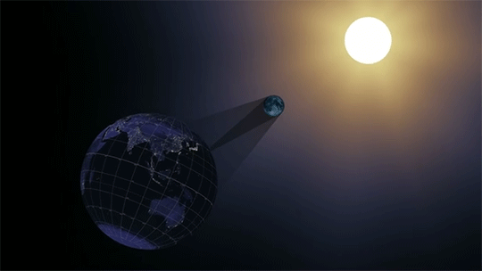
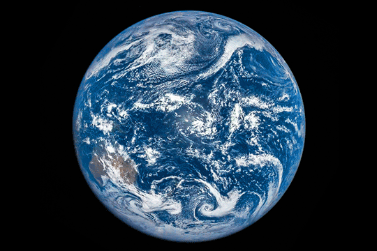
During a solar eclipse, the moon passes between the sun and Earth, casting a shadow down on Earth’s surface. We’ve been studying the moon
with NASA’s Lunar Reconnaissance Orbiter, and its precise mapping helped NASA build the most accurate eclipse map to date.

A view of the United States during the total solar eclipse of Aug. 21, 2017, showing the umbra (black oval), penumbra (concentric shaded ovals) and path of totality (red). This version includes images of the sun, showing its appearance in a number of locations, each oriented to the local horizon.
V I D E O
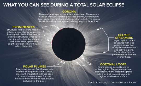
During a total solar eclipse, the moon blocks out the sun’s bright face, revealing the otherwise hidden solar atmosphere, called the corona. The corona is one of the sun’s most interesting regions — key to understanding the root of space weather events that shape Earth’s space environment, and mysteries such as why the sun’s atmosphere is so much hotter than its surface far below.
This is the first time in nearly 100 years that a solar eclipse has crossed the United States from coast to coast. We’re taking advantage of this long eclipse path by collecting data that’s not usually accessible — including studying the solar corona, testing new corona-observing instruments, and tracking how our planet’s atmosphere, plants, and animals respond to the sudden loss of light and heat from the sun.
We’ll be studying the eclipse from the ground, from airplanes, with research balloons, and of course, from space.
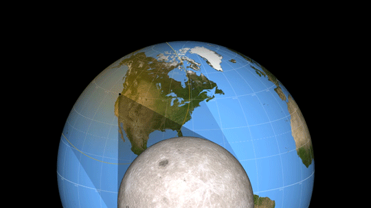
When depicting an eclipse path, data visualizers have usually chosen to represent the moon’s shadow as an oval. By bringing in a variety of NASA data sets, visualizer Ernie Wright has created a new and more accurate representation of the eclipse.
For the first time, we are able to see that the moon’s shadow is better represented as a polygon. This more complicated shape is based NASA’s Lunar Reconnaissance Orbiter’s view of the mountains and valleys that form the moon’s jagged edge. By combining moon’s terrain, heights of land forms on Earth, and the angle of the sun, Wright is able to show the eclipse path with the greatest accuracy to date.
Hear data visualizer Ernie Wright discuss the map in the video above. To see the maps unedited, watch the two videos below.
Watch this video on the NASA Goddard YouTube channel.
V I D E O
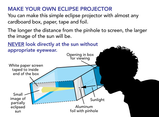
An eclipse is one of nature’s most awesome sights, but safety comes first!
When any part of the sun’s surface is exposed, it’s essential to observe eye safety. whether during the
partial phases of an eclipse, or just on a regular day.
You must use proper eclipse glasses (not sunglasses) or an indirect viewing method
like a pinhole projector.
If you’re in the
path of totality, you may look at the eclipse ONLY during the brief moments of totality.

Credit: NASA's Goddard Space Flight Center/Genna Duberstein
Music: Life Choices by Eric Chevalier
For more information: http://eclipse2017.nasa.gov/
This video is public domain and along with other supporting visualizations can be downloaded from the Scientific Visualization Studio at: http://svs.gsfc.nasa.gov/12412
If you liked this video, subscribe to the NASA Goddard YouTube channel: http://www.youtube.com/NASAExplorer
Or subscribe to NASA’s Goddard Shorts HD Podcast: http://svs.gsfc.nasa.gov/vis/iTunes/f...
Follow NASA’s Goddard Space Flight Center
· Facebook: http://www.facebook.com/NASA.GSFC
· Twitter http://twitter.com/NASAGoddard
· Flickr http://www.flickr.com/photos/gsfc/
· Instagram http://www.instagram.com/nasagoddard/
· Google+ http://plus.google.com/+NASAGoddard/p...

What Does A Solar Eclipse
Look like From Space?
The shadow of the moon during yesterday's solar eclipse was captured in detail by the Himawari-8 Spacecraft in Geostationary orbit.
Published on Mar 9, 2016

Look like From Space?
The shadow of the moon during yesterday's solar eclipse was captured in detail by the Himawari-8 Spacecraft in Geostationary orbit.
Published on Mar 9, 2016
No comments:
Post a Comment